PATHWAYS

The Old way , The Pilgrims Way , The Wansdyke , the Ridgeway , the Fosse way , The Monarch's way ,The Liberty way , The Trafalgar way

The Taunton Stop Line (WW2 defences )

 the Michael line ( line of St Michael churches ) ,

Glastonbury Zodiac ,  the Melkarth Line ( part of the Zodiac )

The Milky Way

The Harrow Way ( The Old way )

The Old Way marked in red with the Pilgrims Way marked in orange, key locations in the Anglo-Saxon Chronicle are labelled black


The Old Way


The Harrow Way (also spelled as Harroway) forms the western part of the Old Way, an ancient trackway in the south of England, dating from the Neolithic period, which is split into a western and eastern part.

Looking up to woodland on the Harrow Way near Overton, Hampshire

 
Wikipedia HERE


The Wansdyke

Most people have heard of Hadrian's Wall, Offa's Dyke and the Antonine Wall, but it is the lesser known Wansdyke in the West Country that is perhaps the most mysterious of them all!

Stretching for 35 miles through the countryside of Wiltshireand Somerset, this large defensive earthwork was built some 20 to 120 years after the Romans had left Britain. Set to a east-to-west alignment, it is thought that whoever built the dyke was defending themselves against invaders from the north. But who were these invaders?

Although there is a fair amount of discussion around this subject, it is thought that it was built by the native Britons as a defensive measure against the Anglo-Saxons who were expanding their territory from the east and the north.

Wansdyke from West to East

HERE


The Ridgeway

By   |  Comments

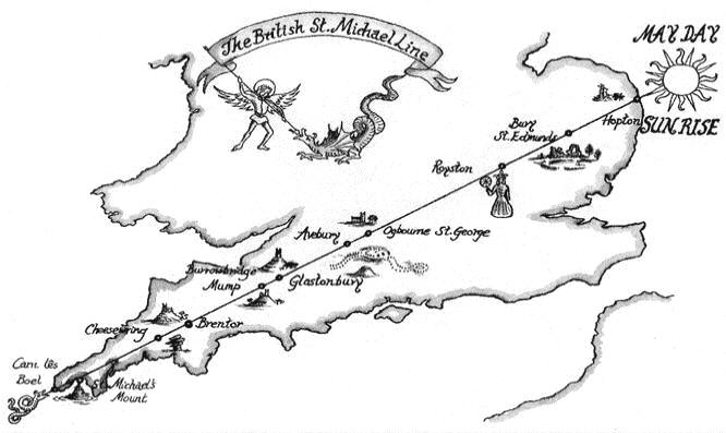
‘Ridgeway’ was a term that originated in Anglo-Saxon times, to refer to ancient tracks that run along the high ridges of hills. They are unpaved, relying simply on the hard ground to provide a suitable surface for travelling on. They provide a more direct route than the modern roads we use today; modern roads tend to be located on more level, flat ground in valleys.

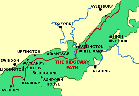
The Ridgeway in England stretches 85 miles (137km) from Overton Hill near Avebury, Wiltshire, to Ivinghoe Beacon near Tring, Buckinghamshire. It has been used for 5000 years by many different groups of people; travellers, farmers, and armies. During Saxon and Viking times, the Ridgeway was useful to provide a track along which to move soldiers into Wessex. In the medieval period, the route would have been utilised by drovers, moving animals to market. The Enclosure Acts of 1750 meant that the Ridgeway became more permanent and the route clearer, and it became a National Trail along with 14 others in England and Wales, in 1973. It is a public right of way.

Map of the Ridgeway

HERE


The Fosse Way


The Fosse, or Foss Way, is the first road we know of locally and it still exists today. Built around 47AD soon after the Roman Conquest it runs straight betweenCirencester Corinium) and Bath (Aqua Sulis). It crosses the Avon at White Walls near Easton Grey. The whole road ran from Exeter (Isca Dumnoniorum) to Lincoln (Lindum Colonia) and when built was the frontier with the still unconquered west of England and Wales. It probably included a defensive ditch – hence the name.

http://www.athelstanmuseum.org.uk/todays_transport_roads.html
HERE


The Taunton Stop Line

Taunton Stop Line

From Wikipedia, the free encyclopedia
Demolition chambers under a bridge over the Bridgwater and Taunton Canal — later filled with concrete and now appearing larger than they were originally.
The Taunton Stop Line was a World War II defensive line in south west England. It was designed "to stop an enemy's advance from the west and in particular a rapid advance supported by armoured fighting vehicles (up to the size of a German medium tank) which may have broken through the forward defences."
 The Taunton Stop Line was one of more than 50 similar defensive lines that were constructed around England, all designed to compartmentalise the country to contain any breakthrough until reinforcements could arrive. Stop Lines used a combination of geography and construction to make continuous defences. The innermost and longest was the GHQ Line. They were constructed as part of a package of field fortifications planned under the leadership ofGeneral Sir Edmund Ironside, the newly appointed Commander-in-Chief, Home Forces.

The Taunton Stop Line ran north-south for nearly 50 miles (80 km) throughSomerset, Dorset andDevon, roughly from Axminster to Chard along the River Axe, then along the Great Western Railway to Ilminster, the railway and Chard Canal to Taunton, the Bridgwater and Taunton Canalto Bridgwater, and the River Parrett to the coast near Highbridge.

 
Highbridge was also the starting point for the east-west GHQ Line.[2]


Wikipedia HERE


The Monarch's way

The Monarch's Way is a 615-mile (990 km)long-distance footpath in England that approximates theescape route taken by King Charles II in 1651 after being defeated in the Battle of Worcester.

It runs from
Worcester via Bristol and Yeovil to Brighton. All of the footpath is waymarked. The waymark is yellow and shows a picture of the ship Surprise above the Prince of Wales three-point feathered crown which is superimposed on a Royal Oak tree (which is at Boscobel House) in black. 
Monarch's Way sign.JPG

wikipedia HERE

The Liberty way


An artists impression of the exitement in Lyme Regis when The Duke of Monmouth landed on its shore.

This Map of the route taken by James, Duke of Monmouth" leading up to the Battle of Sedgemoor was published by Lyme Regis author, George Roberts, in his history in 1844.

HERE
 

The Trafalgar way


 The Trafalgar way


Axminster was on the route of
The Trafalgar Way overland from Falmouth, Cornwall to the Admiralty in London in 1805 and there is a plaque commemorating this fact in the town centre.

In 1805, after the Battle of Trafalgar, news of the victory over the French and Spanish fleets took several week to arrive in England. The Battle took place on 21 October 1805, more than a thousand miles south of the nearest home port.

Lt John Lapenotiere's journey

Admiral Collingwood charged the 35 year old Lt John Lapenotiere, Captain of HMS Pickle to carry his despatch of the news of the victory, and the death of Admiral Nelson to the Admiralty in London. He was to personally hand over the report.

HMS Pickle arrived in Falmouth on 4 November and Lapenotiere immediately hired a post-chaise to journey to London. He kept accounts of the cost of the journey, which took 36 hours at a cost of £46 19s 1d, or six months pay for a young lieutenant. He made 21 stops on the journey to change horses - one of these stops was at Axminster

.

The Re-enactment - 2005

In the summer of 2005, on the 200th anniversary of the Battle of Trafalgar and the epic journey of Lapenotiere, a re-enactment took place. A young actor, Alex Price journeyed from Falmouth to London, visiting each of the 21 stops to present a copy of the despatch that Lapenotiere carried, to each place. The route is named the Trafalgar Way in commemoration.


wikipedia
HERE

The Michael Line

In the late 1980s two researchers into ancient mysteries began a remarkable journey of discovery across southern Britain. Their quest began at St Michael's Mount, and led them to Glastonbury, Avebury and the east coast, and included a great number of ancient sites, some famous and many that had almost been forgotten. Their discoveries as they travelled along the St Michael Line, a countrywide alignment of sites dedicated to St Michael, have deep implications for our understanding of why these places have been so important in previous ages, and why so many people are drawn to visit them today.


The British St. Michael Line
more  HERE


The Melkarth Line

The Melkarth Line is the equinox line of the Temple of the Stars. It is defined by the three-sided arrow-head that is King Alfred’s Tower and its very deliberate arrow-shot through Bruton church, Hornblotton church, the third-eye of the Sagittarius/Hercules figure, through Park Wood (the centre of the Glastonbury Zodiac) and into the very Bull’s Eye of Taurus and beyond. Precision accuracy on a grand scale!
more from Yuri Leitch's website  HERE

The Milky Way

THE MILKY WAY

from Scorpion’s sting a river springs
its foamy waters , new life brings
In  things long dead and things unborn
here flies the Eagle and the Swan
through Cepheus and Cassiopea

through Perseus and the Charioteer
the starry water flows

Orion holds his arm on high
it soaks the feet of Gemini
and ploshes round their toes

it flows between Orion’s dogs
and here the flush of mud and frogs
and broken things and froth and foam
becomes a milky unicorn

and when at last it reaches shore
a ship will sail for ever more